
700 5th Avenue, Suite 2000
P.O. Box 34019
Seattle, WA 98124-4019
(206) 684-8600
Seattle Permits
Tip
sdci
Seattle Department of Construction
and Inspections
— part of a multi-departmental City of Seattle series on getting a permit
Printed on totally chlorine free paper made with 100% post-consumer ber
www.seattle.gov/sdci
Site Plan Requirements
Updated July 1, 2024
Applications for City of Seattle Master Use Permits
(MUPs) and construction permits require site plans. This
Tip will assist you in preparing a site plan. It lists informa-
tion that must appear on site plans submitted with per-
mit applications and provides examples of preliminary,
basic, and enhanced site plans.
For general information on standards for plans and draw-
ings, as well as helpful hints and guidelines on how to
prepare a plan, refer to Tip 106, General Standards for
Plans and Drawings, and Tip 103A, Site Plan Guidelines.
If your project site is in an environmentally critical area
(ECA), reference Tip 103B, ECA Site Plan Requirements,
for details on what additional items should be included
in your site plan. Reference Tip 220, Lot Coverage,
Height and Yard Standards for Homes in Neighborhood
Residential Zones, for site plan details if your project
comes within 2 feet of the height limit or is taking advan-
tage of sloping-lot height bonus provisions in Seattle's
Land Use Code (SMC Title 23).
What is a Site Plan?
A site plan is an accurate drawing or map of a property
that shows its size and shape; and the size, shape
and location of man-made and natural features (such
as buildings, structures, driveways, and trees) on the
property. Site plans show both what currently exists on
the site and what physical changes you wish to make to
the site.
You may choose to contact SDCI to ask questions
about what you may do on a site. If so, you will need
to have a preliminary site plan to discuss. A preliminary
site plan contains enough information to help staff
understand the scope of your project. We can assist you
in identifying codes, requirements, and processes that
could impact your project.
To find out what permits are required for a proposed
project and what plans you will need to prepare, contact
the SDCI Applicant Services Center (ASC), www.seattle.
gov/sdci/about-us/who-we-are/applicant-services-
center, (206) 684-8850.
NOTE: Be aware that the information provided to you
can be only as reliable as the information you provide.
Information given at the ASC is advisory only and
does not constitute approval of an application.
Types of Site Plans
A preliminary site plan is a rough version of your site
plan designed to help resolve preliminary questions.
A basic site plan may be submitted for preliminary ap-
plication site visit (PASV) during intake to satisfy the SDCI
requirement for smaller projects, including: small commer-
cial alterations and additions, changes of use not affecting
parking, truck loading, vehicle access, or residential (one-
and two-family dwellings) additions and alterations and
detached accessory structures less than 2,000 square
feet in area and without new vehicular access.
An enhanced site plan is required for more complex
projects, such as construction of a new single-family,
multifamily, or commercial project.
Preliminary Site Plan
The information listed below is sufficient for site plans
used for coaching and pre-submittal conferences. The
information for the public right-of-way does not need to
be prepared by a licensed surveyor at this point; it is in-
tended as general information only. You need to submit
a preliminary site plan when you submit your preliminary
application.
Note: We accept a less-detailed or "simple" preliminary
site plan for projects including interior-only tenant
improvements or alterations. The simple site plan must
show street name, property lines with dimensions,
general size and location of the building(s) on the site,
property addresses, legal description, assessor's parcel
number, and North arrow.
103

SDCI Tip #103—Site Plan Requirements page 2
LEGAL DISCLAIMER: This Tip should not be used as a substitute for codes and regulations. The applicant is responsible for compliance
with all code and rule requirements, whether or not described in this Tip.
The following information is required:
1. Address of project.
2. Owner's name.
3. Legal description of the property, including any
easements and project numbers of short plats or lot
boundary adjustments.
4. King County Assessor's parcel number (property tax
account #).
5. King County recording number for any easements
or other pertinent legal features.
6. North arrow pointing to the top of sheet and consis-
tent across all sheets.
7. Property lines, dimensions and bearings.
8. Dimensions and right-of-way limits in addition to
roadway widths of adjacent streets (by name), alleys
or other adjacent public property.
9. Curbs, sidewalks, and street trees: type, location,
and dimensions.
10. Street and alley improvement type (asphalt, con-
crete, gravel, etc.).
11. The boundaries of steep slopes, steep slope buf-
fers, wetlands, wetland buffers, riparian manage-
ment areas, and any other ECA areas, per Tip103B,
Environmentally Critical Area Site Plan Requirements.
12. SDCI building identifiers for sites with more than one
building.
13. Location of the pedestrian path to each dwelling
unit and the primary entrance to each building.
14. If existing or proposed building structures (e.g:
building overhangs, chimneys, gutters, sky-bridges,
tunnels, underground parking, etc.) extend into,
over, or under the ROW, a utility easement, or
known utility for which there is no easement, the
dimensions of these structures and their locations
must be provided.
15. Location and dimensions of all driveways, parking
areas, and other paved areas (existing and pro-
posed).
16. General location, size, and shape of any structures
presently on the site and of those proposed for con-
struction; including buildings, retaining walls, patios,
decks, porches, rockeries, and driveways (existing
and proposed).
17. For existing and proposed structures, the front, side
and rear distances from structures to property lines, and
distances between structures, porches and decks.
18. For projects subject to the provisions of SMC Chapter
25.11, Tree Protection, you must show the following:
Location, species, and diameter at 4.5 feet
above the ground of all Tier 1, Tier 2, Tier 3,
and Tier 4 trees, including off-site Tier 1, Tier 2,
Tier 3, and Tier 4 trees with canopies overhang-
ing and/or roots extending onto the lot.
Tree protection area per SMC 25.11.060.A for
all Tier 1, Tier 2, Tier 3, and Tier 4 trees that will
be retained during development.
Tree protection fencing for all Tier 1, Tier 2, Tier
3, and Tier 4 trees that will be retained during
development. SDCI’s Tree and Vegetation Pro-
tection Detail must be included in the plan set.
Basic Site Plan
The information listed below is sufficient for site plans
submitted for the following types of projects:
Small commercial alterations and additions
Change of use not affecting parking, truck loading,
vehicle access
Residential (one- and two-family dwellings) additions
and alterations and detached accessory structures
less than 2,000 square feet in area without new
vehicular access
Include everything required on the preliminary site plan,
as well as the following information, to create a basic
site plan. Numbers 19-29 are the additional items
required for a basic site plan.
The following information is required:
19. The drawing's scale (min. 1" = 10').
20. Specific location, size, and shape of all existing and
proposed structures, including buildings, retaining walls,
patios, decks, porches, rockeries, and driveways.
21. A location plan is required when repair and/or minor
interior alteration to an existing structure
is proposed.
22. Street and alley improvement dimensions.
23. Include site lot coverage calculations.
24. Identification of proposed work, including proposed
changes to the physical features of the site or existing
structures. Clearly distinguish between existing and
proposed features. Statements such as "Existing
wall to remain" are acceptable call-outs.
25. Location and dimension of all window wells, fire-
places, chimneys, etc.

SDCI Tip #103—Site Plan Requirements page 3
LEGAL DISCLAIMER: This Tip should not be used as a substitute for codes and regulations. The applicant is responsible for compliance
with all code and rule requirements, whether or not described in this Tip.
26. Center elevation and developed roadway at 25-foot
intervals if a change to access or parking is pro-
posed.
27. Identify existing and finished grade elevation of
driveway at property line, and at garage entry, if a
change to access or parking is proposed
28. Curb cut width and distance from adjacent property
lines. (Label curb cuts as "existing" or "proposed.")
29. Identify all physical restrictions to site access (utility
poles, rockeries, street trees, Metro bus stops, etc.)
if a change to access is proposed.
Enhanced Site Plan
Include everything required on the preliminary and basic
site plans. Numbers 30-44 are additional items required
for an enhanced site plan.
The following information is required:
30. Elevations and contour lines with labeled contour
intervals on sloping sites or where earth grading is
proposed (2-foot intervals).
31. Identify top and bottom of steep slopes (as defined
in SMC 25.09) and show dimensions from slope
top/bottom to the building(s).
32. Identify drainage ditches, natural watercourses, and
culverts.
33. All proposed and existing street trees and other
landscaping in the public right-of-way.
34. Sewer mains (sanitary only {PPS} and/or combined
sewers {PS}).
35. Storm drains {PSD}, catch basins, and inlets.
36. Water mains, fire hydrants, and water meters.
37. Power poles, street lights, signal and transit poles,
overhead system, bus zones, street signs, etc. adja-
cent to the subject property.
38. All other elements between the pavement edge and
property line (such as side sewer, electrical ducts
and vaults, electrical conduits, handholes, ditches,
culverts, curb ramps, etc.).
39. On-site stormwater treatment, infiltration, or deten-
tion systems.
40. Calculations demonstrating compliance with appli-
cable Land Use Code development standards.
41. For street improvement plans (SIPs) refer to the City
of Seattle's standard plans. Standard plans 002 and
003 provide information related to standard symbols
and abbreviations, which are required when submit-
ting plans to SDOT.
Site Plan Examples
Site plan examples are included on the next few
pages. Figure 1 shows a preliminary site plan; Figure
2 shows a basic site plan; and Figure 3 shows an
enhanced site plan.
For More Information
Additional information on requirements and assistance
with site plans are available from:
King County Assessor
www.kingcounty.gov/depts/assessor.aspx
Department of Assessment Real Estate Office
7th floor, King County Administration Building
500 Fourth Ave
(206) 296-7300
Seattle Department of Construction and Inspec-
tions (SDCI)
www.seattle.gov/sdci
Applicant Services Center
(206) 684-8850
Drainage Review Desk
(206) 684-5362
Seattle Dept. of Transportation (SDOT)
www.seattle.gov/transportation
Engineering Records Vault
47th floor, Seattle Municipal Tower
700 Fifth Ave
(206) 684-5132
Street Use Counter
37th floor, Seattle Municipal Tower
700 Fifth Ave
(206) 684-5283
Links to SDCI's Tips, Director's Rules, and Seattle
Municipal Code are available on our website at
www.seattle.gov/sdci.
Access to Information
SDCI Tip #103—Site Plan Requirements page 4
LEGAL DISCLAIMER: This Tip should not be used as a substitute for codes and regulations. The applicant is responsible for compliance
with all code and rule requirements, whether or not described in this Tip.
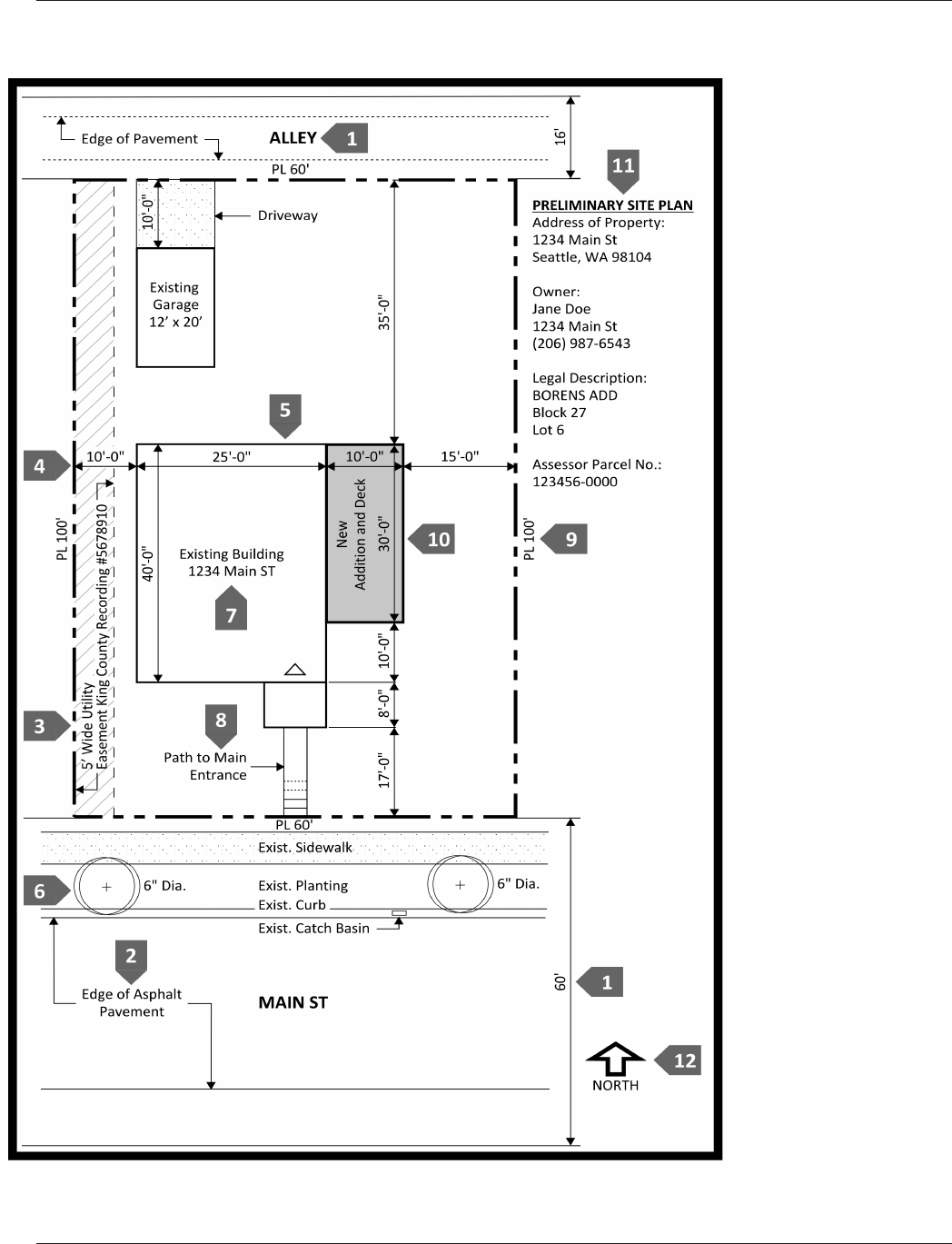
Figure 1: Preliminary Site Plan Elements
Preliminary Site Plan
Elements Key
1. Adjacent streets and
alleys by name and
width
2. Street and alley
improvement type
3. Easements
4. Distances from
structures to property
lines
5. General size and
shape of current and
proposed structures
6. Curbs, sidewalks,
and street trees: type,
location and dimension
7. Building identifiers for
sites with more than
one building
8. Location of primary
entrance
9. Property line
dimensions
10. Proposed work clearly
depicted
11. Address of project,
owner's name, legal
description, and King
County Assessor
Parcel No. (and KC
Recording number
for any easements or
other pertinent legal
features)
12. North direction arrow
SDCI Tip #103—Site Plan Requirements page 5
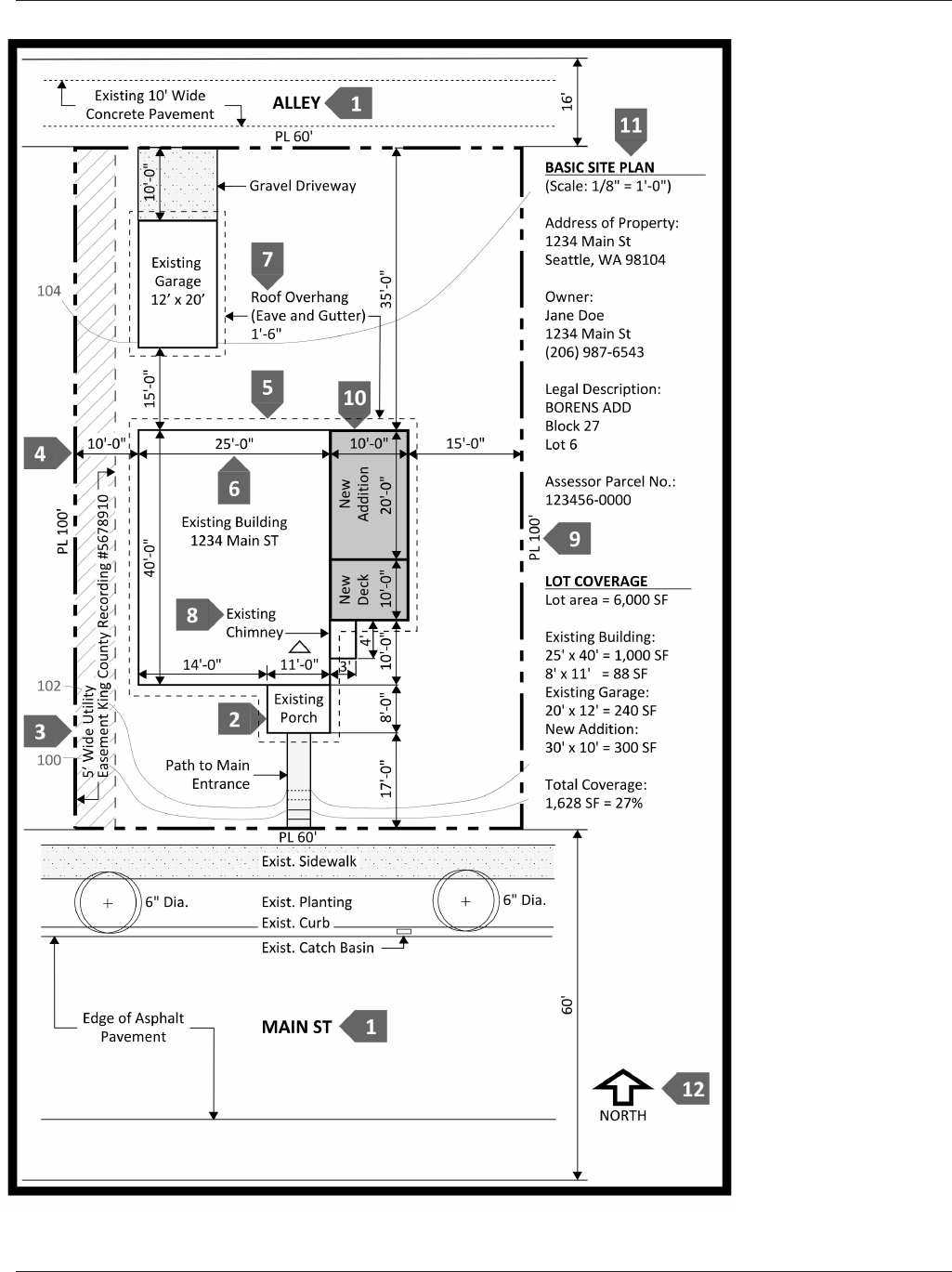
Figure 2: Basic Site Plan Elements
Checklist
1. Streets by name.
2. Labeled and dimen-
sioned porches and
decks.
3. Easements.
4. Setbacks.
5. All roof overhangs
with dotted lines.
Roof overhang is the
total of the EAVE and
the GUTTER.
6. Dimension all exte-
rior walls.
7. Dimension all over-
hangs (dimensions
include gutters).
8. Location and dimen-
sion of chimneys if
they protrude.
9. Property lines and
dimensions.
10. Proposed work
clearly depicted.
11. Address of project,
owner's name, legal
description, and King
County Assessor
Parcel No. (and KC
Recording number
for any easements or
other pertinent legal
features).
12. North direction arrow
SDCI Tip #103—Site Plan Requirements page 6
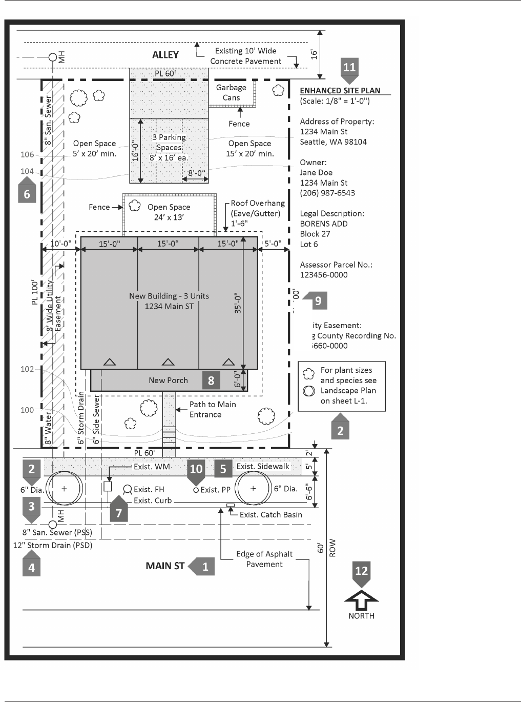
Figure 3: Enhanced Site Plan Elements
Checklist
1. Street by name.
2. Street trees and
landscaping.
3. Sewer mains or com-
bined sewers (PPS).
4. Storm drains (PSD)
and catch basins.
5. Stippling (dotting)
helps to identify
walks and pave-
ments.
6. Ground elevations
and contour lines
on sloping sites or
where proposed.
7. Water mains, fire
hydrants, and water
meters.
8. Locations and
dimensions of all
porches and decks.
9. Property lines and
dimensions.
10. Power poles, street
lights, bus zones,
street signs, etc.
adjacent to property.
11. Address of project,
owner's name, legal
description, and King
County Assessor
Parcel No. (and KC
Recording number
for any easements or
other pertinent legal
features).
12. North direction arrow
LEGAL DISCLAIMER: This Tip should not be used as a substitute for codes and regulations. The applicant is responsible for compliance
with all code and rule requirements, whether or not described in this Tip.
